Baltzell (or Bosel or Bozell) Springs Group
Jackson County
Summary of Features
- Scale—1st magnitude all total, each probably second magnitude
- Scenery—outstanding
- How Pristine?—completely unspoiled
- Swimming—fair to very good, excellent snorkeling
- Protection—unknown
- Wildlife—abundant
- Crowds—some on warm weekends
- Access—moderately difficult, only by water
- Facilities—none at the springs; very good in the adjoining state park
- Safety—watch for alligators if with pets or small children
- Scuba—yes
- Cost—$5 per carload for river access; canoe rental extra
Directions
Young Alligator


Accessible via canoe put-in at Florida Caverns State Park. Address: 3345 Caverns Road, Marianna, FL 32446, 850-482-1228 (www.floridastateparks.org/park/Florida-Caverns). 2.6 miles north of Marianna. From the center of town on U.S. 90, turn right onto Jefferson Street and proceed to the State Park. Once in the park, follow signs to river put-in. The springs are on the left and right shortly outside the park boundary, about a mile upriver.
Canoes are kept at the put-in point on a rack for trips up the Chipola and can be rented at the entrance to the park. From the boat launch, head upstream about a mile to the Baltzell Springs group. Baltzell consists of four springs. The authors have numbered them so that the one farthest upstream is Baltzell #4. Baltzell #2 is the easiest to find and the others can be located in relation to it. The run to Baltzell #2 is on the right side of the river, as you canoe upstream. A few minutes before you get there, you will see a couple of park boundary signs in the trees.
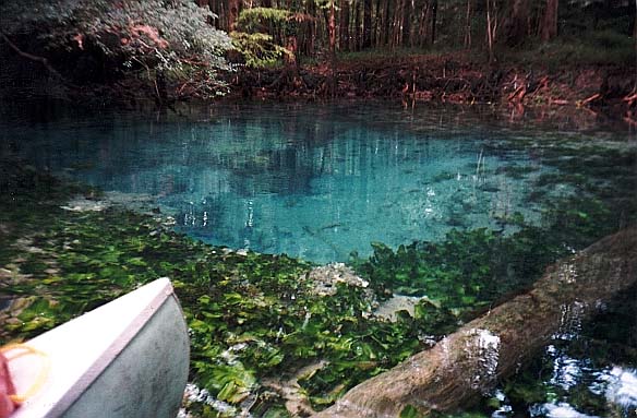
All four springs share a basic description of having very clear blue water (when the Chipola is not high), sudden drop-offs after shallow sandbars or runs, and quantities of small, nibbling minnows. They are about the same size—basins of 20-30 feet in diameter—and depth—10-20 feet. Combined, the springs constitute a sizeable first-magnitude flow; Spring #2 is the largest and is a second-magnitude spring.
>Spring Description
Baltzell #1


Baltzell #1 is the first spring in the group coming from the put-in at the state park downriver. It lies at the back of a run shaped like the number "7." At a spot where the river veers to the right, the mouth of Baltzell #1’s run is straight ahead, to the left (west) of a narrow strip of land/vegetated sandbar jutting out into the river. Follow the run, which is 1-3 feet deep, about 100 feet to the spring. The spring drops away to form an oval basin about 25 feet wide and 40 feet long. There is a east/west trending fissure along the bottom in the center of the pool, about 20 feet long and from 6-12 feet deep. The water in the pool is clear and blue.The bottom is mostly rock and sand and is easily stirred. There are small minnows in the water. In times of high water, this spring can be swampy.
Baltzell #2


Baltzell #2—Perhaps the largest and most attractive of the four springs, #2 has the longest run and is the spring referred to as "Bosel Spring" in Rosenau et al. (1977, p. 179). Look for the clear run entering the Chipola River from the right (east) side. The shallow, transparent run is about 30 feet wide, 1-3 feet deep, and 800 feet long, ending in the main spring. The spring drops off suddenly at the end of the shallow run and forms a semicircular pool 35 feet in diameter. Water flows from a large limestone opening along a fissure about 18 feet long. An opening at about 12 feet leads straight down to a cave. Water also appears to flow from the back of the fissure, forming a prominent slick on the surface. DeLoach reports the cave is small and silty (1997, p. 129). Water in the spring is clear and very blue in the sunlight. The bottom of the spring area is sandy and rocky, with many minnows. The run is covered in aquatic vegetation. There is a very attractive sinkhole behind the head of this spring that can be canoed when the water is high enough.
Baltzell #3


The flowpoint of this spring moved in the 2000s, and then moved back to its traditional location after a couple of years. Baltzell #3—this spring is located just upstream on the right (about 40 feet) from where Baltzell #2's run joins the Chipola. The spring is surrounded by the less-clear waters of the river. It does not have a run, but opens directly into the river. The circular and cypress-lined basin is about 25 feet across and drops off from a sandbar that is covered in vegetation (sometimes submerged, depending on the depth of the river). Cavern walls are clearly evident. The water is an intense clear blue and drops to a crevice about 15 feet down. The crevice is about 15 feet long and is perpendicular to the river. For many years, there was a very large tree at the back of the spring. When the tree fell over, the spring stopped flowing and water instead flowed from a new point 200-250 feet in the woods behind it. That spring had a run that flowed into the original spring pool. After a few years, however, the original springhead began to flow again. The authors speculate that the falling of the giant tree at the former spring somehow interrupted/blocked the normal flow of the spring, and pressure then caused a new spring to erupt behind the old one. Over time, however, the original plumbing reasserted itself.
Baltzell #4


Baltzell #4 is upriver of Baltzell #3 about 100 feet and on the opposite (left or west bank). Like #3, Baltzell #4 also opens directly into the river. It is framed by a vegetated sandbar and large fallen logs, big enough to stand on and jump into the spring. On dates of visit in 1998-2010, there were logs crossing the spring pool above the surface, and two logs below the surface. The spring has a strong vertical flow and boil from at least one limestone opening that appears to be 15-20 feet deep. Water flows outof the vent and over the vegetated sandbar into the adjacent Chipola River.
Use/Access
- The springs, except for #1, are excellent for snorkeling and for cooling off after canoeing, but watch for alligators, especially if you have small children or pets with you. The authors have observed alligators as large as 6 feet in length in this area.
- Access by canoe only; do not put on the land around the springs.
- Spring #2 was featured in the March 1999 issue of National Geographic, page 47.
- For Spring #2, thick-leafed water plants with yellow flowers in summer cover the bottom of the clear run, except for a small fenced-off area onthe right as you approach the spring. The fence is to keep people fromusing the spot to disembark onto the land, which is posted "private property" in large yellow signs in the trees.
Local Springiana
At the bridge near the boat launch in the state park is a man-made channel above the spot where the river went goes underground. The river emerges about 1/4 of a mile downstream. In the early 1900s, a "ditch" (channel) was built to float logs downstream. The channel looks almost natural now, and if it were not for the signs, you might think the river continued above ground, but in a narrower channel. This disappearing act is like that of other rivers such as the St. Marks, Santa Fe, and Aucilla. Canoes are not allowed in the "ditch"--paddling upstream is the only option.
The spring name has been corrected by state officials, and is now known as Baltzell after a landowner near the spring. The names "Bosel" and "Bozell" are bastardizations of the correct name that took hold overtime.
Personal Impressions
These four springs—three of which (#s 1, 3, & 4) are within 300 feet of each other, form a magnificent "spring quartet." Their unspoiled character, easy accessibility, good swimming, excellent snorkeling, clear water, and beautiful setting are a unique combination and make them a favorite of the authors. The State of Florida needs to extend the boundaries ofthe state park to prevent development at these springs. One spring (#2) has a house nearby, and while the others do not, their protection should be a priority.
Nearby Springs
- Blue Hole Spring
- Merritt's Mill Pond Springs (Blue, Shangri-La, Twin Caves, Indian Washtub, Hole-in-the-Rock, Gator)
- Sandbag Spring
- Spring Lake Springs (Black, Double, Gadsen [or Gadsden], Millpond, Springboard)
Other Nearby Natural Features
- Three Rivers State Park
- Falling Water State Park
- Torreya State Park
- Apalachicola Bluffs and Ravines Preserve