Camp La No Che (or Sulfur) Springs
Lake (or Volusia?) County
Summary of Features


Directions (Address and phone: 41940 Boy Scout Rd, Paisley, FL 32767, 352-669-8558, http://camplanoche.com/)
From Altoona, go 7.1 miles east on State Road 42 from its intersection with State Road 19. Turn right (SE) onto Maggie Jones Drive just before SR 42 makes a 90-degree turn to left. Go 0.3 mile, then turn right (south) onto Boy Scout Road. Take sand road until it ends at camp office. Must obtain permission and directions or guide from office to see spring, which is another 1/3 mile to the right on sand roads. Google map link: www.google.com/maps/place/Camp+La-No-Che/@28.9543711,-81.5366604,15z/data=!4m2!3m1!1s0x0:0xc5c632d4018cc0e?sa=X&ved=0ahUKEwiM98itj9XVAhVQ0WMKHeq-BRsQ_BIIejAK
Spring Description
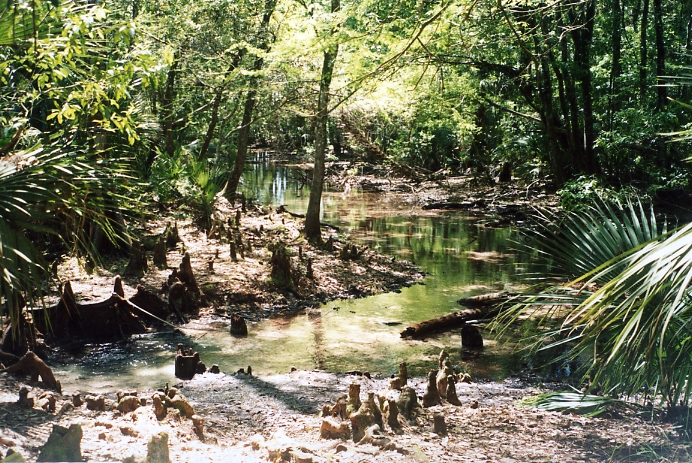
The springs are set in a thickly wooded area. The main flow point is a shallow limestone opening at the base of several tree roots and cypress knees. The visible portion of the vent is about 3 feet deep and creates a pronounced boil about one yard in diameter and 18 inches below the adjacent land surface. Small particles and pebbles are tumbled by the flow. There are rotting bits of an old retaining wall or dock/platform in the main spring pool/alcove. The flow creates a small alcove (perhaps 6 feet in diameter) and then widens into a shallow (1-2" deep) run. The run is joined after about 30 feet by the run from a smaller spring which begin about 85 feet away. This spring is slightly small than the main spring, with a pool about 4 feet in diameter, about a foot deep, and with a mild boil or slick on the surface. The two springs and their individual runs form a "y" and then combine to flow flow in a 25-foot-wide run about 300 feet through the woods to Lake Norris.
The vent area is fringed with white sulfur deposits and some algae (not a lot of algae and not strings of it), and there is a fairly strong sulfur odor in the water. An alligator bellowed nearby on JF's first date of visit (July 9, 2003), and deer were seen near the pool. The bottom of the pool was sandy and muddy, and the pool and its run are canopied by a semitropical hardwood forest. Land rises on one side of the spring to the adjacent camping area and sand roads. The run was blocked by logs in two dams JF's second date of visit (March 17, 2004), but the logs were removed on this date. As a result, the run narrowed by several feet and became more shallow in places.
Use/Access
- The spring is located in the Camp La-No-Che portion of the Winn Dixie Boy Scout Camp, which includes camp areas, pavilions, bathrooms, trails, a firing range, an office, and other buildings and facilities.
- Permission must be granted to visit the spring.
- JF was teaching a group of 5th Graders from an elementary school about springs, and instructed the students on how to remove the log dams at the spring.
- Local Springiana
- JF was told that the remnant retaining wall/dock was build in the 1940s when the area around the spring was used for hunting and the spring was used as a swimming hole/pool.
Personal Impressions
The main spring is very attractive. The interested visitor may or may not be able to access it. It is located down a tangle of sandy roads, and the author would not have been able to find it without the friendly assistance of the camp staff.
Nearby Springs
- Alexander Springs
- Fern Hammock Springs
- Juniper Springs
- Sweetwater Spring
- Silver Glen Springs
- Silver Springs
- Salt Spring
- Orange Spring
Other Nearby Natural Features
Lake Woodruff Wildlife Refuge
Welaka State Forest
Tiger Bay State Forest
Withlacoochie State Forest
Ocala National Forest