Rhodes Springs
Leon County
Summary of Features
- Scale - 2nd magnitude
- Scenery - fine
- How Pristine? - remnants of flume in run and adjacent to dirt road, otherwise very unspoiled
- Swimming - none
- Protection - fair
- Crowds - none
- Access - very good
- Facilities - none
- Safety - good
- Scuba -no
- Cost - free

Directions
From Tallahassee, take U.S. 319 south to State Road 363 (Woodville Highway) south to Natural Bridge Road east toward Natural Bridge. Turn right at Old Plank Road; springs are on the immediate right.
Spring Description
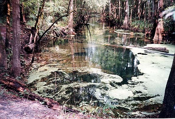
Rhodes is a pair of two small and attractive springs that lie in a fringe of dense forest adjacent to an area of extensive logging. Rhodes is a spring-sink combination or Karst Window (see below). The two springs well up from crevices about 100 feet apart. Each upwelling creates a small pool and run. After 50-75 feet, the two runs join, then flow for another 200 feet before disappearing into a sink at the edge of the road. If viewed from the air through the canopy of trees, the springs system would look like a "Y." The run is about 10 feet wide and a few feet deep except at the vents and the sink. There is evidence of an old log flume in the run, which ends at the edge of Old Plank Road. There is a gentle counterclockwise swirl of water going down into the sink. The water has been clear every time the authors visited. It can have a green tinge because it is canopied and there is abundant vegetation and some algae in the water. Just beyond the springs is a small sink, and just beyond that is Natural Bridge Road.
Note: Based on new classification system by hydrologists, Rhodes is now characterized as a "karst window" (where the rise and sink of water from the Floridan Aquifer is visible) and not a spring.
Use/Access
- A path leads along the south side of the run to the two vents. Watch for snakes and spider webs. The spring/sink combination can be walked in a few minutes. The land is heavily vegetated.
- A development just south of the spring built a boardwalk to the spring, which is accessible from within the development only.
- The springs are within walking distance of the Natural Bridge Monument, which has restrooms, monuments, and some interpretive information on the Civil War fight that occurred at the site.
Local Springiana
- The spring is a former water source for local residents, and is still used for water by hunters who can conveniently fill a barrel from the road where the spring run ends.
- Ferguson et al. (1947) describe several other springs in the Rhodes/Natural Bridge area, only some of which Rosenau et al. were able to locate during their research in the 1970s. Rosenau contains directions for these springs (1977, pp. 238-9, 243), some if not all of which may be known to locals.
Personal Impressions
The appearance of the end of the short spring run just a few feet off Old Plank Road is surprising—almost startling. The run simply ends right at the road, and it looks as if the road is a manmade impediment.
Nearby Springs
- Horn Springs
- Indian Springs
- Natural Bridge Spring
- Newport (or Sulfur) Spring
- St. Marks Springs
- Unnamed St. Marks Sulfur Springs #1-3
- Wakulla Springs
- Other unnamed springs near Natural Bridge
Other Nearby Natural Features
- St. Marks Wildlife Refuge
- Wacissa River/Slave Canal
- Apalachicola National Forest
- Econfina River State Park
- Leon County Sinks Park
- Wakulla Spring State Park
