Webbville Springs
Jackson County
Summary of Features

Directions
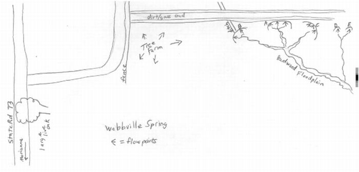
From U.S. 90 in Marianna, go north on State Highway 73 for approximately 6.1 miles. Turn right onto dirt/clay road. Continue approximately 300 feet until road makes a 90-degree turn to left. Look for dirt/grassroad on right across fence at edge of pine tree farm. Walk on dirt road about 0.3 mile to springheads A-C on right adjacent to the road. Flow area A is at coordinates 30.50.358N/85.20.080W, and flow area E is in the woods/swampy area at 30.50.361N/85.20.050W.
Spring Description
The main spring flows are at the base of a 10-12 foot bank below the dirt road. Water issues from several points in five primary areas corresponding to the rough map. The three main flows (A-C) are within 150 feet of each other. Each is a series of seeps or small flows of clear and odorless water.
The three primary flows join within 150 feet and form a creek that is approximately 3-6 inches deep and 4-6 feet wide. The bottom of the creek is sandy, and the spring run flows through an area of dense floodplain forest. A small amount of algae was growing in spots, and minnows, frogs, and snails were seen in the run. There are ferns along the banks, and deer tracks and other animal signs were visible.The run is joined by the combined output of at least two additional flows (D and E) from the NE. These two flow points are smaller and in an area that is at the edge of forest and swamp to the east of flowpoints A-C. The total combined flow is estimated to be third magnitude. The run forms the north fork of Baker Creek, which subsequently flows into the Chipola River. There may be additional flows that the authors did not locate. A ditch empties into springhead B, and there was some trash around the springs--bottles, cans, bits of fencing and metal.
Use/Access
No public access. The dirt/grass road is fenced off.
Nearby Springs
- Tanner Springs
- Daniel Spring
Other Nearby Natural Features
- Florida Caverns State Park
- Torreya State Park
- Falling Waters State Recreation Area
- Apalachicola National Forest
- Apalachicola Bluffs and Ravines Preserve